IOC/GLOSS Technical Visit to the Brazilian Naval Directorate
of Hydrography and Navigation
2-6 September, 2002
Mr. Patrick Caldwell
National Coastal Data Development Center
(NOAA/NESDIS/NODC/NCDDC)
Final Trip Report, October 3, 2002
Index
1. Overview
2. Background Discussions
3. Data Processing Methodology and Software
4. Historical Sea Level Data for Brazil
5. Present Tide Gauge Network: State of Rio de Janeiro
6. Present Tide Gauge Networks in Brazil
7. Future Plans in Support of GLOSS and National Networks
8. Other International Data Collaborations
9. Final Words
Appendices
1. Contacts
2. JASL Brazil Holdings: August2002
3. PSMSL Brazil Holdings
4. IAGS-USCGS (NOAA/NOS) Historic Holdings for Brazil
5. Hourly Data Provided to JASL by BNDO
6. GLOSS Station Status as of 5 September, 2002
7. Action Items
1. Overview
Mr. Patrick Caldwell, data manager for the Joint Archive for Sea Level
(JASL), a collaboration between the National Oceanic and Atmospheric Administration
(NOAA) and the University of Hawaii (UH) Sea Level Center (UHSLC), was selected
by the GLOSS group of experts to make a technical visit to the Brazilian
Directoria de Hidrografia e Navegacao (DHN) da Marinha (Directory of Hydrography
and Navigation of the Navy). Janice Trotte, GOOS Coordinator for Brazil at
DHN, set up the technical agenda and guided logistical arrangements. The primary
two reasons for the visit were 1) to review historical DHN sea level holdings
of GLOSS sites in Brazil with an aim of making available quality-controlled
data for the international sea level centers and 2) to discuss steps for
upgrading the Brazilian GLOSS network to allow a secured data flow to international
permanent archives and initiate at least a few key stations for the GLOSS
fast delivery system. The visit greatly uplifted DHN's motivation toward
these purposes.
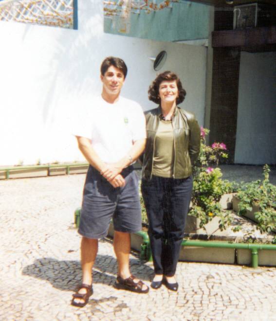
Photograph: Patrick Caldwell and Janice Trotte at the Navy Hotel at the
end of the visit.
2. Background Discussions
The first morning of the visit was dedicated to sharing background information
regarding past, present, and future operational activities of the UHSLC and
DHN. The audience was entirely DHN staff (Appendix 1).
Mr. Caldwell began with a presentation of UH professor Dr. Klaus Wyrtki's
motivation for measuring sea level and the resulting tide gauge networks
which unfolded starting in the 1970s. Specifics on tide station site selection
criteria and instrumentation were given. The discussion led into the present
status of the UHSLC global network with a detailed review of the primary instrumentation,
with emphasis on the acoustic sensor. One of the important points is that
the data are acquired at the UHSLC in near-real time via the internet and
the UHSLC has developed web browser tools for analysing the station health
and the data quality as well as directly accessing the data. The future plans
include a continuation of the fast delivery system for a time lag on the
order of a month for public assess to preliminary data (GLOSS Fast Delivery
) and an even faster turnaround on the order of a few days for the Global
Ocean Data Assimilation Experiment (GODAE).
Mrs. Trotte gave a presentation on DHN involvement with the IOC and other
international programs such as PIRATA. Although the DHN has a long history
of collaboration with IOC, DHN's national hydrographic and navigational priorities
have overwhelmed the ability of satisfying the international expectations.
In regards to sea level, the primary obstactles have been the lack of qualified
personnel to process the data along with a high naval personnel turnover
rate and a lack of funds for supporting station observers as well as toward
upgrading obsolete equipment for which spare parts are not available. On
a positive note, DHN support of PIRATA for other data streams (buoys, hydrographic
stations) has been successful. The new Vice-Admiral of DHN, Admiral Neto,
met with NOAA Admiral Lautenbacher in Paris in June 2002 with agreements
to set up working groups in support of GOOS and GLOSS efforts.
Cp. Fernanda gave a talk on the organization of DHN and emphasized the
creation in 1998 of the Centro for Hidrography de la Marinha (CHM), which
includes the Brazilian National Data Bank and the Department for Navigational
Safety. The latter has three main sections: Geodetic Surveys, Data Analysis,
and Tides. The primary goal is to provide hydrographic services in support
of navigation. The CHM has various software tools for digitizing and processing
sea level data, as well as for making products such as harmonic constituents,
tide tables, monthly mean sea level values, and long-term means for chart
datum application. The CHM provides training courses to tide station observers
and technicians. Most DHN stations are within military ports or national ports
(the Brazilian Ports Authority), with whom DHN has very good working relations.
A copy of her Power Point presentation was given on CDROM to Mr. Caldwell.
After the background talks, Mr. Caldwell was introduced to Vice-Admiral
Neto who gave a kind welcome. He noted DHN intends to focus more attention
on GLOSS.
3. Data Processing Methodology and Software
Mr. Caldwell presented the SLPR2 (JASL) software package to the CHM (Appendix
1) over a two day period (in portuguese). The CHM is well equiped with a
fleet of IBM-PC compatible machines, some with internet. On the second day,
Claudio Neves of Universidade Federal de Rio de Janeiro (UFRJ) and Roberto
Teixeira of Instituto Brasileiro de Geografia e Estatisticas (IBGE) along
with two students from UFRJ attended the demonstration. Hourly data from Forteleza
IAGS historic data were used as an example. Time constraints did not allow
"hands-on" training by the participants, yet all aspects of the package except
the monthly calibration steps were slowly demonstrated. Examples of correcting
timing shifts and erroneous peaks as well as interpolating short gaps with
the predicted tide method were shown. Discussion of the filter to create
daily and monthly values followed in addition to demonstrations of utilities
to plot the filtered data, make differences among stations, and to plot the
differences.
Cp. Fernanda gave a demonstration of the Franco software system, which
directly accesses the Banco Nacional de Dados Oceanograficos (BNDO). Sophisticated
tidal analysis and tidal statistics can be readily produced. It also provides
quality control routines using residuals as a basis. The system is in unix,
linux, and MS Windows. Future plans call for adoption of the Thompson filter.
SC. Neide Arauto detailed the use of MARESCAN, a software system for scanning
analog rolls via a software system consulted out by DHN to the UFRJ. She
reckons that efforts that used to take a day now only takes a few minutes.
The software is easy to use with built in quality control checks. It was suggested
that this type of scanning software be made available to the GLOSS community.
Action Item 1. At the next GLOSS Experts meeting, a review of available
software packages for scanning analog charts should be made. The Brazilian
MARESCAN could be made available for a wider audience.
In review of the existing software above, it appears the CHM has no shortage
of good software and hardware tools for digitizing and processing data. CP.
Fernanda noted she may switch to the SLPR2 (JASL) system instead of the
Franco software, since the former appears easier to apply. Although CHM
has very good tools at their disposal, the high turnover of personnel and
slow learning curve for using this software has hindered rapid availability
of incoming data.
4. Historical Sea Level Data for Brazil
Sea level data has systematcially been collecting in Brazil starting in
the 1940s. First, a note is given regarding the holdings at the international
sea level data centers and secondly, and more importantly, the status of
historical records at DHN is described.
A summary of JASL holdings for Brazil as of August 29, 2002 is given in
Appendix 2 and in Figure 1. Of significance is the recent recovery of hourly
sea level data recorded during the 1950-60s by the Inter-American Geodetic
Survey (IAGS) of the US Coastal and Geodetic Survey (USCGS) branch of the
Dept. of Commerce, USA (Appendix 3). The NOAA National Ocean Service (NOS)
provided paper tables of hourly data along with tide staff readings for
six sites: Belem, Fortaleza, Recife, Salvador, Canavieiras, and Rio de Janeiro.
The data were digitized by the UHSLC and reviewed by the JASL during May-August
2002. Metadata are not complete at present; however, as much information
about the historic series as available along with a copy of the data in hourly,
daily, and monthly formats were provided to DHN, UFRJ, and IBGE on CDROM
and to the Instituto Oceanografico de Universidade de Sao Paulo (IO-USP)
by FTP. One of the important outcomes of the technical visit was learning
of the availability of historical station information documentation and photographs
maintained at the IBGE. Copies of Salvador were obtained with promise for
the others to be mailed in the near future. This critical metadata will
greatly enhance the value of the data. Action Item 2. Email to Roberto Teixeiro
Luz of IBGE to remind him of the need for copies of the historical station
descriptions of all IAGS sites. One interesting fact that was uncovered
is that the IAGS site for Rio de Janeiro was located at Fortelaza de Santa
Cruz on the Niteroi side at the mouth of Guanabara Bay. This location is
subject to rough surf and strong currents relative to Ilha Fiscal.
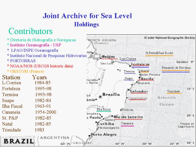
Figure 1. JASL holdings status as of August 2002.
In addition to the historic IAGS data, CDROMs of the WOCE Version 3.0
Fast-Delivery Sea Level and Shipboard ADCP Data Assembly Centers were provided
to DHN, IFRJ, and IBGE. The former contains the complete JASL archive as
of August 1, 2002.
All data that enter the JASL are forwarded to the PSMSL, which is the
primary international agency for mean sea level and has much longer time
series of monthly means for most Brazilian sites, as shown in Appendix 4
and Figure 2. Most of the recently recovered IAGS hourly data are for the
period 1955-1968 while PSMSL holds monthly means over the period 1949-1968.
Also, the PSMSL has some Brazilian series for which hourly data have not
been made available to the JASL. Of important notice is that two of the
IAGS series (Salinopolis and Imbatuba) are missing from the recent data
recovery by the JASL. Action Item 3. Contact NOAA/NOS to learn if hourly
paper tables for Imbituba and Salinopolis could be located and to see if
the missing years in the first batch (1949-1954) could be found. Imbituba
is of special national interest because it is the basis for the national
geodetic datum. As a followup (1 October 2002), it was discovered that the
US National Archives may have the 1949-1954 data and the full series for
the other two sites on microfiche. Mr. Steven Lyles of NOAA/NOS is investigating.
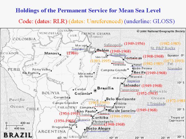
Figure 2. PSMSL Holdings.
The Banco Nacional dos Dados Oceangraficos (BNDO), based at DHN, is the
Brazilian National Oceanographic Data Center. They maintain a computer-ready
data archive and technical library as well as a huge warehouse of analog
charts and paper documents. The primary source for sea level data at the
BNDO is from the DHN and through DHN's collaboration with the Brazilian Ports
Authorities. However, data from other sources have also been received.
There have been over 300 tide gauge sites in Brazil although a vast majority
of those were for very short periods and many of those did not have tide
staff readings or regular geodetic leveling. It was noted that over 60,000
analog charts (one day per chart) are backlogged for digitizing. For each
site, a station description file is maintained with information on latitude
and longitude, instrumentation, bench marks, and other pertinent notes. Tide
staff readings generally are annotated directly onto the daily analog charts.
Geodetic surveys of the tide staff to the bench marks are maintained in separate
files.
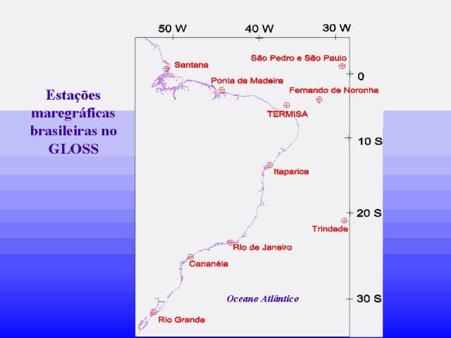
Figure 3. GLOSS and GLOSS-affiliated sites in Brazil.
Inventories and status of BNDO holdings for GLOSS sites were presented
by Cp. Maria Fernanda. GLOSS and GLOSS-affiliated sites are shown in Figure
3. Hourly data are maintained in files, with one file for each period related
to the same datum. It is presently not clear how to tie the various segments
together. A copy of hourly data holdings for GLOSS sites was made available
on CDROM by Cmd. Briones for all GLOSS and GLOSS-affiliated sites, as summarized
in Appendix 5. Station description files for some sites were provided. Action
Item 4. Request a copy of BNDO station description files for Santana and
Madeira.
A thorough review of the BNDO historic holdings will be made in the coming
months at the JASL. At present it is safe to say that other than the IAGS
historic series and the Cananeia station, which is maintained by IO-USP,
the only GLOSS site with a fairly continuous long record is Ilha Fiscal in
Rio de Janeiro. For this series, Dr. Claudio Neves of UFRJ reports that a
thorough quality control and calibration was performed on the hourly data
for all years by Geraldo Da Silva, DHN, in collaboration with UFRJ. BNDO has
not acquired a copy of this series, mainly because of concerns for maintaining
two versions of the same site. Action Item 5. Request a copy of the quality
controlled hourly data for Ilha Fiscal from Geraldo Da Silva, DHN, Dept.
de Ensino. A copy of a master's thesis, "Contributions to the Study of Mean
Sea Level in the State of Rio de Janeiro" by Afonso Felipe Dias Kalil, was
provided to Mr. Caldwell by Dr. Neves. The thesis cross-examined hourly sea
level data from several sites in the state over a period of one year and found
a high correlation in the high frequency signals.
As previously mentioned, DHN is actively scanning analog records. SC.
Neide Arauto is the primary operator of the MARESCAN software. All historic
records of Ilha Fiscal are being scanned. The plan is to do a detailed comparison
between the records digitized by hand and those by MARESCAN. Upon acceptable
faith in MARESCAN, continued historical data recovery will be undertaken.
DHN welcomed any outside help in digitizing the backlog of data. Mr. Caldwell
noted that the UHSLC may have resources for at least some of the key series
if supporting calibration information is also available. Action Item 6. Discuss
with Dr. Mark Merrifield, Director of the UHSLC, about the possibility of
digitizing historic analog rolls at the UHSLC for one or two key series.
Regarding oceanic islands of Brazil (Fernando de Noronha, St. Peter and
Paul Rocks, and Trindade Island), bottom pressure sensors have been made
through the 1990s into this decade. However, none of the data have geodetic
links or atmospheric pressure sensors. Also, there is very high uncertainty
of the data quality. None-the-less, Mr. Caldwell requested a copy for review,
noting that the data would only be included in the archive for obviously
clean segments. Due to the oceanographically important location of these islands,
a small bit of data is better than none.
5. Present Tide Gauge Network: State of Rio de Janeiro
The state of Rio de Janeiro has various governmental, academic, military,
and private interests that maintain sea level gauges. Dr. Claudio Neves explained
that a collaborative workgroup was established among key participants of
each agency to ensure quality data and open data exchange.
The DHN operates two gauges in Guanabara Bay: Ilha Fiscal and Ponta de
Armacao, which is located on the dock at the DHN facility in Niteroi. Both
have two gauges. The long-term gauge is the float/well arrangement with an
analog recorder. In 2001, a second well was installed at both sites within
which a DIGILEVEL gauge was deployed (Figure 4). The technology and access
software was developed through a DHN contract with UFRJ. It resembles an electronic
tide staff. It has sensors spaced 1 cm apart along a staff that is housed
in the stilling well. Electronic readings are made at 15 minute intervals.
The data are buffered into a data collection platform (DCP) in the tide station
protective house. The DCP can be interrogated by telephone to directly download
the data at the CHM. This operation is typically performed daily with the
DCP buffer size well over a month. The DIGILEVEL software utilizes Excel
spreadsheets for some of the data analyis and reduction tasks. Intensive
comparisons with the analog series and cross-examination among the two tide
stations are being made. In general, the high frequency signals (tides) agree
very well among the stations and instrument channels.
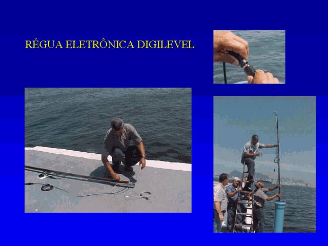
Figure 4. DIGILEVEL Tide Gauge Developed by IFRJ
The IFRJ maintains a DIGILEVEL gauge to the west of Rio near Angra. It
has only been in place a few years. In collaboration with a power company,
the IBGE collects data from a DIGILEVEL based in Macae, which is north of
Cabo Frio. This instrument has only been operating just over a year, but
an analog gauge has been working since 1994. Both channels of data are processed
at IBGE. The analog data are digitized using SURFER scanning software. Each
maregram is digitized twice for quality control. Plans are to replace the
SURFER scanning mechanism with a more sophisticated GIS type system in the
near future. Both data streams receive final quality control with use of the
SLPR2 (JASL) software. R. Teixeira received training in use of JASL software
at the 1993 GLOSS workshop in Sao Paulo.
The data will be made available among collaborators, but Dr. Neves was
reluctant to include the international community. He noted the data will
be made available to the BNDO. Dr. Teixeiro of the IBGE noted that he has
given a copy of some IBGE data to BNDO. He said is was OK to ask him directly
for a copy. Action Item 7. Request to Dr. Teixeiro of the IBGE for a copy
of finalized, calibrated the hourly Macae sea level data.
6. Present Tide Gauge Networks in Brazil
The DHN in collaboration with Brazilian Port Authorities continues as
the primary responsible party for maintaining sea level measurements in
Brazil. As previously mentioned, tight resources at DHN in terms of personnel
and upkeep or upgrading of instrumentation has been very low. Various other
academic, governmental, and private interests operate gauges in Brazil.
The IO-USP continues to maintain sites at Ubatuba and Cananeia. The former
is a test site and has unresolved calibration errors. The latter is a GLOSS
site and is of good quality. The instrument is a float/well analog gauge.
The series began in the 1950s and has very few gaps. Some concern was raised
about the location since it is an estuary and may periodically be influenced
by fresh water runoff. However, the location clearly receives oceanic signals
within the frequency bands from tides to long term sea level rise; thus,
Cananeia is one of the finest available records in Brazil.
The IBGE is the national agency for geodetic datum control, primarily
for terrestrial application. It maintains a CGPS network. The national datum
is presently based on the historic IAGS monthly means sea level series of
Imbituba. Since 1998, IBGE has maintained a float/well analog gauge at this
site. In 2001, a DIGILEVEL gauge was installed from which near-real time data
are available via a telephone modem. As mentioned, a similar arrangement exists
in the state of Rio de Janeiro for Macae, north of Cabo Frio. The IBGE plans
to install the same arrangement (float-well-analog and DIGILEVEL sensors)
at three additional sites in 2003: Salvador, Forteleza, and Santana. A field
trip to Salvador is planned for mid October 2002 to investigate the proposed
gauge location.
In the late 1990s, the Dr. Marcio Vianna was active in setting up gauges
and centralizing data. However, no communication has been made with DHN,
IFRJ, IBGE, or the JASL for over two years. His status is unknown.
It is noted that throughout the country, there are private companies that
maintain gauges for their engineering/port purposes. Pathways for access
to these data are unclear.
7. Future Plans in Support of GLOSS and National Networks
A full day of the technical visit was dedicated to discussions of upgrading
the GLOSS network in Brazil as well as coordinating a national network. Attendees
of the round table discussion on September 5, 2002 from DHN included J.Trotte,
Cm. Briones, and Cp. Fernanda; from IFRJ were C. Neves and D. Muehe; from
the IBGE, R. Teixeira; and finally from the UHSLC, P.Caldwell (Appendix
1). A summary of GLOSS sites is given in Figure 5 (portuguese) and Appendix
6 (english). DHN regrets that other sea level experts in Brazil were not
invited to the round table discussions due to financial constraints. However,
one of the national action items of the session was to form a working group
of all Brazilian sea level experts to improve the GOOS/GLOSS national program.
A review of the existing GLOSS site selection was the first order of business.
It was noted that reassignment of GLOSS sites based on oceanographic and
logistic circumstances be put before the GLOSS group of experts.
The oceanic islands are oceanographically critical for GLOSS, yet due
to the harsh environment, conventional gauges can not be installed. Moreover,
the cost for sophisticated systems for this type of location are prohibited
given the present budget. These should continue as GLOSS sites, but external
resources are required if high quality measurements are desired.
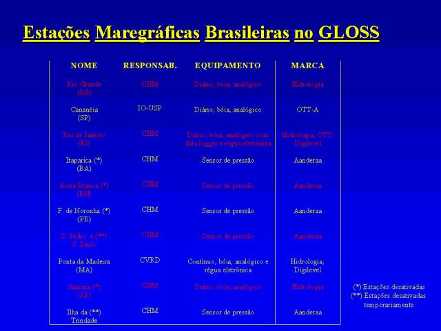
Figure 5. GLOSS Tide Gauge Station Status.
Of the continental sites, only Cananeia and Rio de Janeiro (Ilha Fiscal)
are clearly operational and logically GLOSS. The remaining GLOSS network
should heed consideration of revision. Action Item 8. A recommendation for
the GLOSS group of experts to review the suggestions of the DHN/IFRJ/IGBE/UHSLC
round table discussions of September 5, 2002 for revising the selection of
GLOSS sites along the continent of Brazil. The suggested network would consist
of Forteleza, Salvador, Rio de Janeiro, Cananeia, and Imbituba, with alternative
(secondary) sites at Suape (near Recife), Barra do Riacho (between Salvador
and Rio), and Rio Grande.
The suggestions for an improved Brazilian continental GLOSS network are
based on the desired criteria as described for the UHSLC network: 1) avoid
regions of rough surf or strong currents, 2) avoid fresh water runoff (rivers)
3) away for very active port operations that may damage the station, 4)
adequately deep water, 5) solid foundation (wharf, peir, jetty, etc) for
supporting the station, 6) insurance against vandalism (station observer
or port authority cooperation), and 7) ease of access for the tide observer
and station technicians. The other GLOSS consideration is the placement
of a gauge at roughly 1,000 km intervals along the continent. Brazil has
over 8,000 km of coast.
Starting in the north, both Santana and Porta de Madeira are historic
tide gauge sites that have very little quality data and are located along
very wide, strong rivers. The nearest site in the northern region which
meets the basic criteria as described above is Fortaleza. This site also
has the advantages that the IBGE maintains a VBLI and a CGPS gauge near the
port. The IBGE plans to install a pair of gauges here in 2003. Historic IAGS
data are available from 1949-1968 (monthly means, PSMSL) and 1955-1968 (hourly,
JASL).
Natal has a small harbor and a history of vandalism problems at the tide
station. Very little quality data are available. The IAGS site at Recife
shows good data for this region, but Dr. Neves noted that there is evidence
that the Recife area is settling. Salvador shows the most promise. The existing
GLOSS site, Itaparica, is not working since DHN has moved the gauge to Salvador,
which is just across the harbor. The IAGS series is of very good quality
for this site. A wharf is available within the port with secured protection
from vandalism by the Port Authority. The IBGE operates a CGPS station that
has been leveled to the IAGS bench marks. However, due to the oceanographic
importance of Natal, it could be kept as an alternative site.
The distance from Salvador to Rio (Ilha Fiscal, Figure 6) is over 1000
km. Thus, GLOSS may want to consider a site between these two ports. The
suggested alternative site is Barra do Riacho, which has a good port and
an existing gauge operated by a power company. It was a consensus that the
power company would share the data to enhance public relations. Action Item
9. DHN (BNDO) should request a copy of the hourly data for Barra do Riacho
from the power company. Mr. Caldwell should give DHN a reminder in 6 months.
To the south of Rio de Janeiro and Cananeia is the existing site of Rio
Grande in the southernmost state of the country. The gauge is not well maintained
and has poor data. The M2 tide signal is very weak in this area, with meteorological
tides dominating the series. Thus, application of residuals for quality control
nearly impossible. Imbituba is the closest site which meets the stated site
criteria and is of very important national interest since it is the location
of the national geodetic datum. The IBGE already has a pair of gauges operating
in this port with a nearby CGPS station.
Finally, the discussion was made regarding a Fast GLOSS network. Dr. Mark
Merrifield has offered to install a fast-delivery sea level station for a
tropical, continental site that would enhance PIRATA and GLOSS. DHN has counter-offered
logistical support for this station. The station configuration would consist
of a pair of a tide staff, two Aquatrack acoustic sensors and wells, a Handar
555 data collection platform, UH reference level switches, solar panels,
and satellite atenna. The round table work group suggested Salvador as the
best choice in light of the previously mentioned criteria. There is good
insurance against vandalism due to the excellent security of the Port Authority.
Nautical high-resolution charts for the port were provided by DHN to Mr.
Caldwell for examination by Dr. Merrifield and the UHSLC technicians. A meeting
is scheduled on October 4, 2002 to discuss the issue among the UHSLC experts.
Ideally, a second station of this arrangement could be made available in
the not too distant future for Forteleza for monitoring signals propagating
along the northern coast. Action Item 10. Discuss the selection of Salvador
as the GLOSS site in Brazil for the new UHSLC Aquatrack fast-delivery sea
level station.
8. Other International Data Collaborations
Mr. Caldwell toured the BNDO and divisions of meteorology and oceanography
for navigational support. Comm. Jose Frota Miai, Head of BNDO, along with
GIS expert, Mr. Emanual Cruz, kindly provided a thorough explanation of their
activities. In addition, Capt. Frederico Saraiua, superintendant for Environmental
Information, and Comm. Walter Santos, Head of the Environmental Data Division,
detailed the efforts of their divisions. The network of hydrographic stations
by DHN vessels was depicted in a poster. Mr. Caldwell asked if these data
were unclassified, and if so, if the WDC-A (Sid Levitus) has received a
copy. It was noted that BNDO maintains archives for all Brazilian institutions
as well as DHN cruises and most data are unclassified, with the exception
of a few naval cruises. However very little hydrographic profile data has
been provided to WDC-A. Action Item 11. Inform Sid Levitus that BNDO likely
holds valuable contributions for the WDC-A global profile database. Janice
Trotte has offered her services to facilitate this endeavor.
The BNDO also depicted a poster with use of shipboard ADCP. It was pointed
out that most of the data have not been reduced to absolute, calibrated currents.
Action item 12. Offer BNDO a copy of the UH CODAS software for processing
shipboard ADCP data and request a copy of non-classified data.
9. Final Words
Great thanks to J.Trotte for coordinating the visit and leading the round
table discussions, to Vice-Admiral Neto for his kind hospitality and open
dialog, to
Cm. Briones and Cp. Fernanda for their logistical support and detailed
discussions, and to the visitors from IFRJ and IBGE for their collaboration.
Thanks to all for patience with my portuguese with the spanish twist. Thanks
to the National Coastal Data Development Center for allowing my time to participate
in these very important international coastal issues. And finally, thanks
to the IOC for the sponsorship of the technical visit. It is not easy to
quantify the level of success of the mission, but certainly important topics
were brought into the open and given notice by Brazilian hydrographic leaders,
technical professionals, and oceanographic experts who support sea level
monitoring, research, and application. A continued collaboration among all
of the above will ensure an upgraded GLOSS network for Brazil into the future.
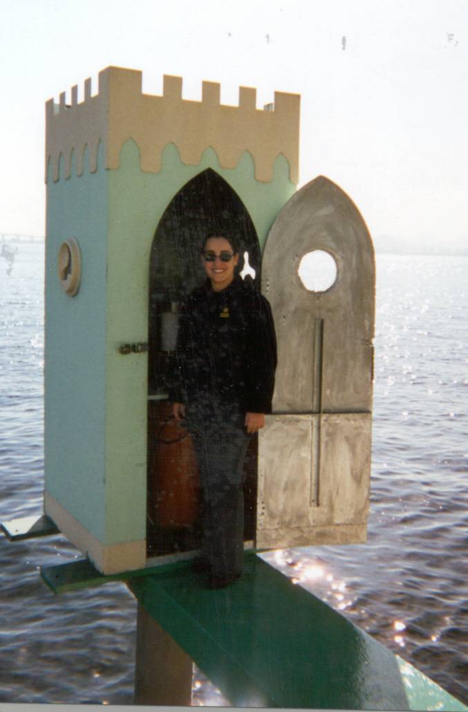
Figure 6. Maria Fernanda (CHM,DHN) at the Ilha Fiscal Tide Station
Appendix 1: Contacts
Brazilian Navy
1. Director of Diretoria de Hidrografia e Navegacao (DHN)
Vice-Admiral Julio Soares de Moura Neto
01@dhn.mar.mil.br 2613-8001
1.GOOS Coordinator for Brazil
Janice Romaguera Trotte 07coi@dhn.mar.mil.br
2613-8013
1. Brazil Naval Hydrographic Center (CHM) of DHN
2. Chief of Geodetic Survey Section
Comm. Alexandre Borges Briones 31@chm.mar.mil.br 2613-8026
2613.b. Chief of Tides Section
Maria Fernanda de Lucena Resende 311@chm.mar.mil.br 2613-8238
List of CHM staff who received UH SLPR2 training
Antonio Menezes Candoso
Jose JunioDa Hora Machado
Ernani de Oliveria
Venceslau Iacillo de Albuquerque (Robusto)
Neide Aparecida Campos Arauto
Vinicius Tomaz de Almeida
Roberto Carlos Pereira de Souza
1. Banco Nacional de Dados Oceanographicos
Comm. Jose Frota Miai, Head of BNDO
Mr. Emanual Cruz, GIS expert, ADCP specialist
1. Environmental Information Division
Capt. Frederico Saraiua
1. Environmental Data Division
Comm. Walter Santos, Division Head,
1. Numerical Prediction
Antonio Fernando Garcex Faria gacez@smm.mil.br 2613-8278
Visitors to DHN for Brazilian SL Network and GLOSS Issues
Claudio Freitas Neves
Universidade Federal de Rio de Janeiro (UFRJ)
Coastal/Ocean Engineering Dept. (COPPE)
neves@peno.coppe.ufrj.br
2562-8730
Dieter Muehe
UFRJ/Geografia
Coastal GOOS Representative for Brazil
dieter@ufrj.br
2714-2457
Roberto Teixeira Luz
Instituto Brasileiro de Geografia e Estatisticas (IGBE)
Dept. Geodesia
roberto@ibge.gov.br,betoluz@hotmail.com
2514-4931
Visit to Instituto Brasileiro de Geografia e Estatisticas
Ricardo de Oliveira Ribas
Tide Gauge Equipment Team
Dept. of Geodesy
rcardoribas@ibge.gov.br
2514-4931
www.ibge.gov.br
Visit to Universidade Federal de Rio de Janeiro
Fabio Nascimento
fabion@pobox.com
2562-8815
Afonso de Moraes Paiva
PENO/COPPE/UFRJ
Physical Oceanography
Cidade Universitaria
Centro de Technologia -C203
mpaiva@peno.coppe.ufrj.br
2562-8729
Appendix 2. JASL Brazil Holdings: August2002
JASL
|
TOGA
|
GLOS
|
STATION
|
COUNTRY
|
LAT
|
LONG
|
QC-YEARS
|
CI
|
201A
|
Axxx
|
199
|
St. Peter&Paul R.
|
Brazil
|
00-55N
|
029-21W
|
1982-1985
|
99
|
202A
|
Axxx
|
197
|
Natal-A
|
Brazil
|
05-45S
|
0035-12W
|
1982-1983
|
100
|
202B
|
Axxx
|
197
|
Natal-B
|
Brazil
|
05-45S
|
035-12W
|
1983-1984
|
99
|
202C
|
Axxx
|
197
|
Natal-C
|
Brazil
|
05-45S
|
035-12W
|
1984-1985
|
100
|
203A
|
Axxx
|
198
|
Fer. de Nor.-A
|
Brazil
|
03-50S
|
032-24W
|
1982-1983
|
100
|
203B
|
Axxx
|
198
|
Fer. de Nor.-B
|
Brazil
|
03-50S
|
032-24W
|
1984-1985
|
100
|
203C
|
Axxx
|
198
|
Fer. de Nor.-C
|
Brazil
|
03-50S
|
032-24W
|
1985-1986
|
100
|
203D
|
Axxx
|
xxx
|
Fer. de Nor.-D
|
Brazil
|
03-49S
|
032-23W
|
11993-1995
|
52
|
204A
|
Axxx
|
265
|
Trindade
|
Brazil
|
220-30S
|
029-19W
|
1983-1983
|
16
|
229A
|
Axxx
|
xxx
|
Belem,USCGS
|
Brazil
|
01-27S
|
048-30W
|
1955-1968
|
96
|
280A
|
Axxx
|
195
|
Ilha Fiscal,Rio
|
Brazil
|
22-54S
|
043-10W
|
1963-1991
|
91
|
281A
|
Axxx
|
194
|
Cananeia
|
Brazil
|
25-01S
|
047-56W
|
1954-2000
|
100
|
283A
|
Axxx
|
xxx
|
Fortaleza-A,USCGS
|
Brazil
|
03-43S
|
038-29W
|
1955-1968
|
95
|
283B
|
Axxx
|
xxx
|
Fortaleza-B
|
Brazil
|
03-43S
|
038-28W
|
1995-1998
|
100
|
284A
|
Axxx
|
xxx
|
T677Termisa
|
Brazil
|
04-49S
|
037-03W
|
1993-1995
|
97
|
707A
|
Axxx
|
xxx
|
Canavieiras,USCGS
|
Brazil
|
15-40S
|
038-58W
|
1956-1961
|
95
|
708A
|
Axxx
|
xxx
|
SalvSalvador,CGador,CG
|
Brazil
|
12-58S
|
038-31W
|
1955-1964
|
92
|
709A
|
Axxx
|
195
|
Rio de Janeiro,CG
|
Brazil
|
22-56S
|
043-08W
|
1955-1968
|
70
|
710A
|
Axxx
|
xxx
|
Suape
|
Brazil
|
08-21S
|
034-57W
|
1982-1984
|
98
|
711A
|
Axxx
|
xxx
|
Luis Corriea
|
Brazil
|
02-52S
|
041-40W
|
1984-1985
|
100
|
712A
|
Axxx
|
xxx
|
Recife,USCGS
|
Brazil
|
08-03S
|
034-52W
|
1955-1968
|
86
|
713A
|
Axxx
|
xxx
|
Recife,INPH
|
Brazil
|
08-03S
|
034-52W
|
1946-1997
|
73
|
726A
|
Axxx
|
xxx
|
Atol de Rocas
|
Brazil
|
03-51N
|
033-49W
|
1999-1999
|
15
|
CI : Completeness Index or percentage of days with available data
Note 713A, Recife is not in the publically open archive due to level uncertainties.
Appendix 3.
IAGS-USCGS (NOAA/NOS) Historic Holdings for Brazil
STATION
|
COORDINATES
|
Observed period
|
At JASL
|
At PSMSL
|
Paper Hourly/CR
|
Belem
|
00 26.9S 048 30.1W
|
1949-1968
|
|
1949-1968
|
1955-1968
|
Fortaleza
|
03 42.6S 038 28.6W
|
1949-1968
|
1995-1998
|
1948-1968
|
1955-1968
|
Salinopolis
|
|
1952-1955
|
|
1949-1956
|
|
Canavieiras
|
15 40 S 038 58 W
|
1952-1961
|
|
1952-1963
|
1956-11956-1961961
|
Recife
|
08 03.4S 034 52.0W
|
1949-1967
|
|
1948-1968
|
1955-1967
|
Rio de Janeiro
|
22 56.1S 043 08.3W
|
1949-1967
|
1963-1991
|
1949-1968
|
1955-1968
|
Salvador
|
12 58 S 038 31.1W
|
1949-1967
|
|
1949-1968
|
1955-1964
|
Paper Hourly/Comparative Readings (CR) are from the US Coast and Geodetic
Survey. The paper data were digitized, quality controlled, added to
the JASL in August 2002.
Appendix 4: PSMSL Holdings
(likely outdated by a year or so)
1572 R
|
21
|
1948 - 1968
|
28 14 S
|
48 39 W
|
IMBITUBA
|
BRAZIL
|
1573 R
|
40
|
1954 - 1993
|
25 01 S
|
47 56 W
|
CANANEIA
|
BRAZIL
|
1574
|
47
|
1944 - 1990
|
23 57 S
|
46 19 W
|
SANTOS
|
BRAZIL
|
1575 R
|
23
|
1954 - 1993
|
23 30 S
|
45 07 W
|
UBATUBA
|
BRAZIL
|
1576
|
1
|
1980 - 1980
|
23 00 S
|
44 02 W
|
ILHA GUAIBA
|
BRAZIL
|
1577 R
|
20
|
1949 - 1968
|
22 56 S
|
43 08 W
|
RIO DE JANEIRO
|
BRAZIL
|
1578
|
28
|
1963 - 1991
|
22 54 S
|
43 10 W
|
IHLA FISCAL
|
BRAZIL
|
1579
|
2
|
1974 - 1975
|
20 30 S
|
29 19 W
|
ILHA DE TRINDADE
|
BRAZIL
|
1580
|
1
|
1983 - 1983
|
20 32 S
|
29 19 W
|
ILHA DE TRINDADE
|
BRAZIL
|
1581 R
|
12
|
1952 - 1963
|
15 40 S
|
38 58 W
|
CANAVIEIRAS
|
BRAZIL
|
1582 R
|
20
|
1949 - 1968
|
12 58 S
|
38 31 W
|
SALVADOR
|
BRAZIL
|
1583 R
|
21
|
1948 - 1968
|
08 03 S
|
34 52 W
|
RECIFE
|
BRAZIL
|
1584
|
2
|
1982 - 1983
|
05 45 S
|
35 12 W
|
NATAL A
|
BRAZIL
|
1585
|
2
|
1983 - 1984
|
05 45 S
|
35 12 W
|
NATAL B
|
BRAZIL
|
1586
|
2
|
1984 - 1985
|
05 45 S
|
35 12 W
|
NATAL C
|
BRAZIL
|
1587
|
1
|
1972 - 1972
|
03 52 S
|
32 26 W
|
FERNANDO DE NORONHA
|
BRAZIL
|
1588
|
2
|
1982 - 1983
|
03 50 S
|
32 24 W
|
FERNANDO DE NORONHA
|
BRAZIL
|
1589
|
2
|
1984 - 1985
|
03 50 S
|
32 24 W
|
FERNANDO DE NORONHA
|
BRAZIL
|
1590
|
2
|
1992 - 1993
|
03 50 S
|
32 24 W
|
FERNANDO DE NORONHA
|
BRAZIL
|
1591
|
4
|
1982 - 1985
|
00 55 N
|
29 21 W
|
ST PETER & ST PAUL R.
|
BRAZIL
|
1592
|
3
|
1993 - 1995
|
04 49 S
|
37 03 W
|
TERMISA
|
BRAZIL
|
1593 R
|
20
|
1948 - 1968
|
03 43 S
|
38 29 W
|
FORTALEZA
|
BRAZIL
|
1594 R
|
8
|
1949 - 1956
|
00 39 S
|
47 23 W
|
SALINOPOLIS
|
BRAZIL
|
1595 R
|
20
|
1949 - 1968
|
01 27 S
|
48 30 W
|
BELEM
|
BRAZIL
|
1596 R
|
1
|
1984 - 1984
|
00 03 S
|
51 10 W
|
SANTANA
|
BRAZIL
|
Appendix 5. Hourly Data Provided to JASL by BNDO.
Each file contains hourly data for a given time segment. A station may
have multiple segments if instrumentation, reference level, or other physical
change occurred to the tide gauge station. The following information was
pulled directly from the file headers.
SITE
|
LAT
|
LONG
|
TZ
|
START(ddmmyyyy)
|
END(ddmmyyyy)
|
AREIA BRANCA(TERMISA)
|
04495S
|
037024W
|
+030
|
04031961
|
04041961
|
|
|
|
|
06061972
|
07071972
|
CANANEIA
|
25010S
|
047555W
|
+030
|
26021954
|
31121993
|
PORTO DO RIO DE JANEIRO(I.FISCAL)
|
22538S
|
043110W
|
+030
|
02021963
|
20041963
|
|
|
|
|
01051963
|
31121963
|
|
|
|
|
14011964
|
24041964
|
|
|
|
|
01061964
|
31071964
|
|
|
|
|
01091964
|
31051980
|
|
|
|
|
01011966
|
24121970
|
|
|
|
|
09081980
|
31101980
|
|
|
|
|
09081980
|
31101980
|
|
|
|
|
01121980
|
31121986
|
|
|
|
|
09111988
|
12052002
|
|
|
|
|
16052002
|
21052002
|
|
|
|
|
25052002
|
28072002
|
CAIS DA PRATICAGEM DO RIO GRANDE
|
32083S
|
052062W
|
+030
|
27061981
|
30071981
|
|
|
|
|
07081983
|
31081983
|
|
|
|
|
17091983
|
29021984
|
|
|
|
|
10031984
|
31081984
|
|
|
|
|
01011985
|
29011985
|
|
|
|
|
05021985
|
20021985
|
|
|
|
|
01031985
|
01071985
|
|
|
|
|
11091985
|
30091985
|
|
|
|
|
12101985
|
24101985
|
|
|
|
|
03111985
|
24111985
|
|
|
|
|
01071987
|
31101987
|
|
|
|
|
01121987
|
04051988
|
|
|
|
|
11051988
|
30061988
|
|
|
|
|
01091988
|
21091988
|
|
|
|
|
28091988
|
30111988
|
|
|
|
|
02011989
|
28111989
|
CAIS DA PRATICAGEM DO RIO GRANDE
|
32083S
|
052062W
|
+030
|
27061981
|
30071981
|
ILHA DE ITAPARICA
|
12526S
|
038413W
|
+030
|
06081974
|
20091974
|
TERMINAL DA PONTA DA MADEIRA
|
02339S
|
044227W
|
+030
|
01011988
|
09021988
|
|
|
|
|
21051988
|
08061988
|
|
|
|
|
14061988
|
31121988
|
|
|
|
|
18111989
|
10121989
|
|
|
|
|
05011991
|
26021991
|
|
|
|
|
01071991
|
30061996
|
|
|
|
|
01051998
|
29051998
|
FERNANDO DE NORONHA (ST.ANTONIO)
|
03490S
|
032241W
|
+020
|
26091986
|
10111986
|
|
|
|
|
01091992
|
04081993
|
FERNANDO DE NORONHA (BAIA DE SE)
|
03523S
|
032256W
|
+020
|
24121968
|
10011969
|
|
|
|
|
13121970
|
13011971
|
|
|
|
|
01061971
|
02071971
|
|
|
|
|
01011972
|
31121972
|
|
|
|
|
08061974
|
29061974
|
|
|
|
|
05101978
|
07121978
|
|
|
|
|
02021981
|
15021981
|
|
|
|
|
01011985
|
31011985
|
SAO PEDRO E SAO PAULO
|
00552N
|
029206W
|
+020
|
18011993
|
22031994
|
PORTO DE SANTANA
|
00034S
|
051108W
|
+030
|
24061957
|
14061958
|
|
|
|
|
05051970
|
30061972
|
|
|
|
|
01011975
|
31121976
|
|
|
|
|
01011984
|
30061985
|
|
|
|
|
14021996
|
06021997
|
SSN - SANTANA
|
00037S
|
051096W
|
+040
|
24051994
|
28021995
|
|
|
|
|
01011999
|
31012000
|
|
|
|
|
01012000
|
31012000
|
ILHA DA TRINDADE
|
20302S
|
029187W
|
+020
|
01011970
|
01021970
|
|
|
|
|
14071970
|
14081970
|
|
|
|
|
01051973
|
01061973
|
|
|
|
|
02111973
|
02121973
|
|
|
|
|
01011974
|
31121975
|
|
|
|
|
01101978
|
12061979
|
|
|
|
|
01061980
|
27071980
|
|
|
|
|
02041981
|
31051982
|
|
|
|
|
19091982
|
18101982
|
|
|
|
|
26101982
|
30111982
|
|
|
|
|
02021983
|
18081983
|
|
|
|
|
02021983
|
18081983
|
|
|
|
|
27111983
|
17051984
|
|
|
|
|
04071984
|
31101985
|
|
|
|
|
19021986
|
15051986
|
|
|
|
|
21051986
|
01051989
|
|
|
|
|
07051989
|
30091989
|
|
|
|
|
24041990
|
26101990
|
|
|
|
|
01111990
|
31121990
|
Appendix 6.
GLOSS Station Status as of 5 September, 2002
A. Continental
|
|
|
|
|
Site
|
Location Type
|
Sensor-type
|
Sensor-status
|
Geod.Lev?
|
Santana
|
river influence
|
float/analog
|
not workingot working
|
no
|
P.Madeira
|
river influence
|
float/analog
|
not working
|
no
|
Natal
|
port
|
float/analog
|
not working
|
yes
|
Itaparica
|
port
|
float/analog
|
not working
|
yes
|
Rio de Janeiro
|
bay/port
|
float+digilev.
|
both good
|
yes
|
Cananeia
|
estuary
|
float/well
|
good
|
yes
|
Rio Grande
|
estuary
|
float/well
|
OK
|
yes
|
B. Oceanic Islands
|
|
|
|
|
Site
|
Location Type
|
Sensor-type
|
Sensor-status
|
Geod.Lev?
|
SP&P Rocks
|
oceanic
|
pressure
|
periodic
|
no
|
Fern. Noronha
|
oceanic
|
pressure
|
periodic
|
no
|
Trindade
|
oceanic
|
pressure
|
periodic
|
no
|
Appendix 7. Action Items
2-6 September, 2002 IOC/GLOSS Technical Visit to DHN
Action Item 1. At the next GLOSS Experts meeting, a review of available
software packages for scanning analog charts should be made. The Brazilian
MARESCAN could be made available for a wider audience.
Action Item 2. Email to Roberto Teixeiro Luz of IBGE to remind him of
the need for copies of the historical station descriptions of all IAGS sites.
Action Item 3. Contact NOAA/NOS to learn if hourly paper tables for Imbatuba
and Salinopolis could be located and to see if the missing years in the first
batch (1949-1954) could be found.
Action Item 4. Request a copy of BNDO station description files for Santana
and Madeira.
Action Item 5. Request a copy of the quality controlled hourly data for
Ilha Fiscal from Geraldo Nogueira Da Silva (Dept. De Ensino, DHN).
Action Item 6. Discuss with Dr. Mark Merrifield, Director of the UHSLC,
about the possibility of digitizing historic analog rolls at the UHSLC for
one or two key series.
Action Item 7. Request to Dr. Teixeiro of the IBGE for a copy of finalized,
calibrated the hourly Macae sea level data.
Action Item 8. DHN (BNDO) should request a copy of the hourly data for
Barra do Riacho from the power company. Mr. Caldwell should give DHN a reminder
in 6 months.
Action Item 9. A recommendation for the GLOSS group of experts to review
the suggestions of the DHN/IFRJ/IGBE/UHSLC round table discussions of September
5, 2002 for revising the selection of GLOSS sites along the continent of
Brazil. The suggested network would consist of Forteleza, Salvador, Rio de
Janeiro, Cananeia, and Imbituba, with alternative (secondary) sites at Suape
(near Recife), Barra Racho (between Salvador and Rio), and Rio Grande.
Action Item 10. DHN (BNDO) should request a copy of the hourly data for
Barra do Riacho from the power company. Mr. Caldwell should give DHN a reminder
in 6 months.
Action Item 11. Discuss the selection of Salvador as the GLOSS site in
Brazil for the new UHSLC Aquatrack fast-delivery sea level station.
Action Item 12. Inform Sid Levitus that BNDO likely holds valuable contributions
for the WDC-A global profile database. Janice Trotte has offered her services
to facilitate this endeavor.
Action item 13. Offer BNDO a copy of the UH CODAS software for processing
shipboard ADCP data and request a copy of non-classified data.