SEA LEVEL VARIATION IN THE COAST OF MOZAMBIQUE
A contribution to the Africa-America GLOSS News - 2002
The case of the Maputo harbour
By Jafar Ruby and Cândida Sete (*)
(*) National Institute of Hydrography and Navigation - INAHINA
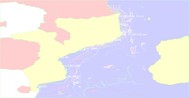
Figure 1- Tidal station network in the coast of Mozambique.
Four sea level observation stations are presently operating in permanent
basis in the Mozambique coast, and have provided an important contribution
supplying data for operational and research applications. Apart from the
actual observation network, tidal data have been obtained for different
locations from the past and have been used to generate different products
and inputs to different studies. Two of the tidal stations (Inhambane and
Pemba) are also part of the GLOSS network.
Tides in the coast of Mozambique, are of semi-diurnal type (two low
waters and two high waters a day) with a daily inequality of about 10-20
centimeters in Maputo, Inhambane, Chinde, Quelimane and Angoche, to about
30-40 centimetres in Beira, Pebane, Ilha de Moçambique, Nacala,
Pemba and Mocímboa da Praia.
For the purpose of this study, the main tidal characteristics of the
Maputo harbour will be summarised and the seasonal variation of sea levels
will be presented in this report.
Tidal Amplitudes
The tidal range in the Mozambique coast varies quite considerably between
extreme neap tides and extreme spring tides. Tidal amplitudes vary over
the year and along the coast.
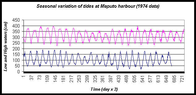
Figure 2- The variation of tides at Maputo harbour.
The tidal range at Maputo harbour varies from less than 30 centimetres
to about 380 centimetres (reference to chart datum) during extreme spring
tides. Tidal amplitudes vary over the year between 80 centimetres during
neap tides and about 300 centimetres during spring tides (see figure below).
Time (day x 2): Because of the semidiurnal type of the tides, two to
obtain the exact should divide each scale number of days.
Mean Sea levels
The determination of the mean sea level is of high interest, particularly
for geodesy.
Mean sea level is obtained by means of filtering the oscillations due
to astronomical tide. It means that the mean sea level is also influenced
by meteorological (or oceanographic) conditions.
For the estuaries in particular, the mean sea level varies with the
river flows. For example, during floods the mean sea level at Chinde in
the Zambezi River mouth increases by some 50 centimetres.
Long period mean sea-level variation can be caused by isostatic movements
of the land, ice melting, sea water density variation, pressure and wind
regime variation, etc.
In order to obtain a mean sea-level value that can be used with satisfactory
severity as geodetic vertical reference, long time series of mean sea-level
values are required to resolve (by averaging) the oscillations observed
during a large number of years.
Fixed benchmarks were implemented in the main port locations along the
coast of Mozambique. The objective was to help monitoring the relative
changes of the mean sea level as function of balance between the sea level
rise due to the global warming of the planet, and the vertical displacements
of the coast due to geological movements.
Daily mean sea-level values are filtered from the hourly-observed data.
Monthly and yearly mean values are calculated and used to monitor the mean
sea level along the coast.
Consistent results as to the investigation of sea level trends in the
coast of Mozambique do not show up with clear evidence as yet, relying
in the need for longer and uninterrupted time series, and subject to the
application of improved quality control techniques.
Pre-processing techniques were developed and have been used at the Institute
of Hydrography and Navigation of Mozambique, envisaging exceeding observed
diversions in heights (use of cubic and lagragian polynomials), and diversions
in phase (use of the Spline function). The effectiveness of these techniques
can be read from the inherent residuals.
Processed mean sea level values were used to plot and analyse its variation
against different factors as follows:
Maputo Tidal Station (Lat. = 25º 58.5' S, Lon. = 32º 34.2'E)
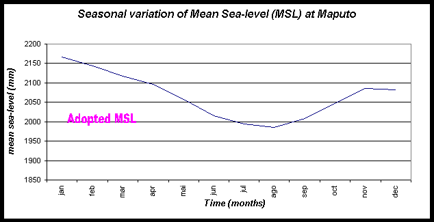
Figure 3- mean sea level at Maputo all over the year obtained from about
21 years of data.Characteristic
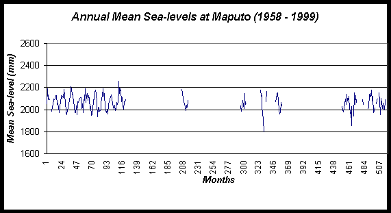
Figure 4- Annual mean sea level plots for Maputo harbour observed data
from 1958 to 1999.
Adopted mean sea level at Maputo area is 200 cm above Chart Datum.
Mean sea level in Maputo may be influenced by the total rainfall/runoff
pattern of the catchments areas of the Incomati, Maputo and Matola river
basins, as the tidal station lies in the delta of these rivers. It is otherwise,
quite clear from the Figure 3 the influence of the rain regime of these
rivers. The monthly mean sea-level variation curve indicates a minimum
during May to October and a maximum during November to April, which corresponds
exactly to the dry and wet seasons of the above-mentioned rivers, respectively.
REFERENCES:
Manual de Hidrografia - J. A. Barahona Fernandes - Instituto Hidrográfico,
Lisboa 1971.
Marés. Fundamentos, Análise e Previsão - A. S.
Franco - Directoria de Hidrografia e Navegação, Brazil 1ª
edição 1997.
The alternating open and closed inlet of Bilene lagoon, Mozambique;
influence of waves and tides and of human intervention - M.Achimo, J. Mugabe,
F. Cuamba, D. Chemane, J. Ruby, E. T. James, P. L. de Boer.
Physical Oceanography of coastal waters - K. F. Bowden, 1983.